
SwampButt Underwear Askes How long will Houston’s September heat last?
Here’s what weather models say.
The first official day of fall arrives in just a couple of days. But Southeast Texas continues to experience significantly above-average heat.
NOTE: This article was published in the Houston Chronicle September 20, 2026.
Since the start of September, Houston’s average high temperature has been 93.6 degrees, and the average low has been 76.2. Together, that’s an overall average of 84.9 degrees, which is tied for Houston’s second-warmest start to September in the city’s recorded history.
According to weather models, the heat isn’t going anywhere — at least not for the next five days. However, conditions could finally shift as we push into the end of the month and the start of October.
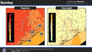
Here’s what to expect. Houston will have a mild, muggy morning on Sunday, with lows hovering in the upper 70s through 8 a.m. Temperatures will rise steadily through the late morning, likely reaching 90 degrees by around noon. Afternoon highs are expected to reach 94 to 95 degrees, but with humidity, “feels like” temperatures are expected to rise above 100. Skies will be mostly sunny, but scattered clouds will continue to stream in from the Gulf.
NWS Houston/Galveston
A few isolated thunderstorms are likely to form, generally along and south of the Interstate 10 corridor. Houston’s overall rain chances will be around 20%, with a few isolated downpours and occasional lightning possible. However, most of Southeast Texas will stay dry.
Staying hot: A weak cold front is expected to move into parts of North Texas early in the week, bringing slightly cooler temperatures and enhanced rain chances to areas like Waco, Dallas and parts of West Texas. However, the front will stall out well before reaching the Houston metro area, keeping local temperatures quite hot.
From Monday through Thursday, high temperatures in Houston are expected to range from 94 to 97 degrees each day – about 6 to 8 degrees above average for late September. Morning lows will also stay consistent, in the upper 70s to near 80 degrees.
Because of high atmospheric moisture in the area, an isolated shower or weak storm will stay possible through the middle of the week. Overall chances, though, will only be around 10% to 20% each day.
Any cooler weather coming?
Temperatures are likely to fall slightly as we push into the upcoming weekend. According to the National Blend of Models, high temperatures in Houston are likely to sit near 92-93 degrees by Friday and Saturday, but that is still slightly warmer than average for late September.
After that, long-range weather models suggest the pattern could become a bit more active, raising the chance of a cold front in the area by the end of September or the very beginning of October. However, because this is at least a week away, uncertainty remains high.
By the first full week of October, the GEFS ensemble weather model projects temperatures in Southeast Texas near or slightly above average, with highs in the upper 80s to near 90 degrees. While still warm, at least it’s a step in a slightly cooler direction.